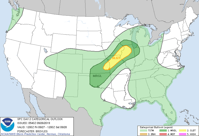
Day 2 Convective Outlook
NWS Storm Prediction Center Norman OK
1240 AM CDT Thu Sep 26 2019
Valid 271200Z - 281200Z
...THERE IS A SLIGHT RISK OF SEVERE THUNDERSTORMS FROM PARTS OF THE CENTRAL PLAINS TO THE MID MISSISSIPPI VALLEY...
...SUMMARY... Thunderstorms associated with wind damage, large hail and an isolated tornado threat will be possible Friday afternoon and evening from the central Plains to the mid Mississippi Valley.
...Southern and Central Plains/Lower Missouri and Mid Mississippi Valleys...
West-southwesterly mid-level flow will be in place on Friday from the Great Plains into the Great Lakes region. At the surface, a cold front will advance southeastward across the central Plains, lower Missouri Valley and mid Mississippi Valley. Ahead of the front, surface dewpoints are forecast to be in the upper 60s F which should result in moderate instability by midday. As surface heating takes place and low-level convergences increases along the front, thunderstorm development will be likely along the majority of the front from eastern Kansas to northern Illinois.
NAM and GFS forecast soundings along the front for 00Z/Saturday have MLCAPE values generally from 2,000 to 4,000 J/kg with 35 to 40 kt of 0-6 km shear. This should support supercell development with cells that remain discrete. However, strong low-level convergence and mid-level flow parallel to the front should result in mostly linear development as the event progresses. Supercells early in the event or rotating cells embedded along the line should have an isolated tornado and large hail threat. Wind damage will also be possible especially as a squall line organizes near the front during the early to mid evening.
...MAXIMUM RISK BY HAZARD...
Tornado: 5% - Slight
Wind: 15% - Slight
Hail: 15% - Slight
..Broyles..
09/26/2019
 RSS Feed
