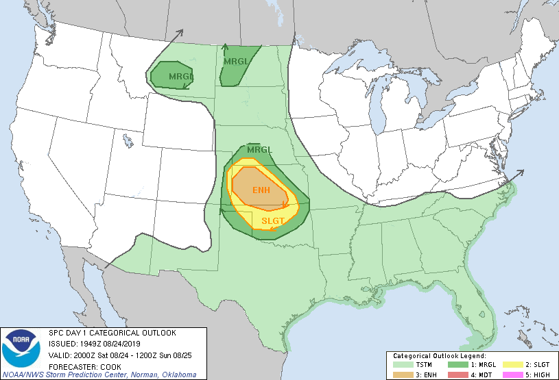
Day 1 Convective Outlook NWS Storm Prediction Center Norman OK
0249 PM CDT Sat Aug 24 2019 Valid 242000Z - 251200Z
...THERE IS AN ENHANCED RISK OF SEVERE THUNDERSTORMS FROM WESTERN AND CENTRAL KANSAS INTO FAR NORTHERN OKLAHOMA...
...SUMMARY... The greatest severe-storm threat this evening into tonight is from central and western Kansas into northern Oklahoma, with severe wind, damaging hail and a few tornadoes possible. ...20Z Outlook Update... Expected evolution of convection remains in line with the ongoing convective outlook. Initiation of storms is expected to occur across far northern Kansas this afternoon/early evening although specific timing remains uncertain. A few of these storms may already be underway across western and southwestern Nebraska. The expectation is that convection will congeal into a southeastward-moving complex that will migrate through the Enhanced area and reach northern Oklahoma late tonight, with additional storms expected in west-central and southwestern Kansas during the afternoon. A more isolated threat for severe storms will exist across central/western North Dakota and also central Montana. ..Cook..
08/24/2019 .PREV DISCUSSION... /ISSUED 1130 AM CDT Sat Aug 24 2019/ ...KS/northern OK through tonight... An initial convectively enhanced midlevel trough is pivoting northeastward over northern KS/southern NE, as an upstream trough over southeastern WY/northern CO moves toward western KS by this evening. In the wake of widespread overnight convection, steeper midlevel lapse rates will spread east-southeastward from CO toward western KS, above low-level moisture advecting northwestward from central KS and OK. Clouds will linger today across most of KS aside from the southwest, but the combination of increasing midlevel lapse rates/low-level moisture and surface heating in cloud breaks will boost MLCAPE into the 2000-3000 J/kg range by mid-late afternoon across western KS.
Substantial uncertainty exists regarding the location(s) and timing of convective initiation this afternoon into early tonight. One scenario appears to be for convection to start late this afternoon/evening near the KS/NE border, in a zone of low-level warm advection along the southern flank of the MCV. This area will be just north of the stronger deep-layer vertical shear, so there would be a tendency for storms to cluster/merge and begin to grow upscale and move southeastward on congealing outflow into early tonight. The environment farther south into the western half of KS will be conditionally favorable for supercells with large hodograph curvature/SRH in the low levels, and effective bulk shear near or greater than 40 kt. However, the focus for storm initiation south of the MCV/warm advection is a bit more nebulous across western KS this afternoon, other than weak ascent preceding the midlevel trough moving southeastward from CO. If surface-based storms can form across western KS, all severe hazards will be possible. Will largely maintain the previous outlook to cover the possibility for an MCS central KS overnight, and for evening supercells in western KS that could move toward northwest OK.
...Western ND this afternoon/evening... A surface trough could provide a focus for thunderstorm development this afternoon/evening across western ND. Forcing for ascent will be weak, along with vertical shear, which suggest that marginally severe hail and gusty outflow winds will be the main concerns.
...Central/eastern MT this evening... Some high based convection should form later this afternoon/evening across central MT, in advance of an embedded speed max moving eastward from northern ID. Though low-level moisture will be limited, inverted-v profiles and an increase in midlevel flow prior to stabilization of the boundary layer could support isolated storms with strong outflow gusts.
 RSS Feed
